|
|
|
|
|
|
| April 27, 2024 |
|
Potent winter storm surges northward under mountains of snow 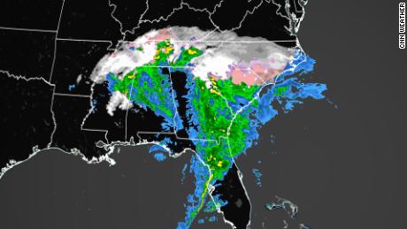
RALEIGH, NC - A major winter storm that unleashed dangerous conditions with snow and ice across the Southeast on Sunday will continue to take a turn to the north and northeast and charge up the Eastern Seaboard into Monday. The heaviest snowfall will accumulate across interior parts of the Northeast, unloading accumulations that could bring some communities to a standstill. A blast of winter weather will impact big cities along the I-95, but hazards will shift over to heavy rain and strong winds as the storm progresses.
Winter storm warnings and winter weather advisories were plastered across much of the Northeast prior to the storm's arrival. After dumping heavy snow on parts of the Plains and Midwest, the storm system took aim at the Tennessee Valley and the Southeast. AccuWeather forecasters say 100 million Americans will feel the effects of the winter storm. Multiple states across the East Coast have already called a state of emergency in preparation for the winter storm. The governors of Virginia, North Carolina, South Carolina and Georgia all announced a state of emergency for their respective states. Along the I-95 corridor, where the center of the storm is likely to track, warm air is forecast to be drawn in from the Atlantic Ocean which will cause rain to fall during most of the storm. But, even the major cities of Washington, D.C., Baltimore, Philadelphia, New York City and Boston have the potential to be hit with a brief dose of snow or a wintry mix on Sunday night. The wintry precipitation can rapidly cover roads and make for slippery travel at the onset of the storm before any accumulation is washed away by rain in these places as the night progresses. From that stretch of the I-95 corridor to the beaches, several hours of heavy rain and strong winds could trigger urban flooding and sporadic power outages. On the barrier islands and along the shores of some of the back bays, minor to moderate coastal flooding is likely due to the storm’s easterly winds and the astronomical effects of the approaching full moon on Monday. Gusts will frequently reach 40-60 mph along the coast. Story Date: January 17, 2022
|
      |