|
|
|
|
|
|
| April 26, 2024 |
|
Potent 'bomb cyclone' to lash Northeast with heavy snow, howling winds 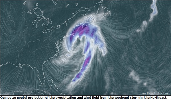
A potent winter storm is forecast to wallop the East Coast on Friday and Saturday, forecasters said, with heavy snow and howling winds possible from the Carolinas to Maine.
"Confidence is increasing that a significant winter storm will create considerable impacts Friday through the weekend from the Mid-Atlantic through the Northeast," the National Weather Service said Wednesday. The Weather Service added: "Heavy snow is most likely in parts of New England, but is also possible farther south along the East Coast, including the major I-95 metro areas from New York City to Washington, D.C." AccuWeather meteorologist Bernie Rayno said "this could be a huge snowstorm for New England." Well over a foot of snow is likely in some areas, he said. In addition, the Weather Service warned that "significant coastal impacts are possible in the Northeast, including coastal flooding and beach erosion. Strong winds may cause blowing snow and some damage. Hazardous travel conditions are likely in parts of the region." According to AccuWeather, should the storm strengthen to its maximum potential, hurricane-force winds of 74 mph or greater will be felt in southeastern New England and could cause power outages. While the storm's exact path is uncertain, it's likely it will become a "bomb cyclone," a so-called winter hurricane that occurs when a storm strengthens by rapidly intensifying or quickly dropping in atmospheric pressure. A bomb cyclone, or bombogenesis, occurs when the central pressure of a storm crashes by 24 millibars or greater within 24 hours, AccuWeather said. When the pressure plummets, winds rush in toward the center of the storm at a faster pace. The winds can carry a great deal of moisture with them and unleash that in the form of copious amounts of precipitation. If the air is cold enough, heavy snow and blizzard conditions can ensue, according to AccuWeather. The storm is also likely to gain nor'easter status, characterized as a large, intense area of low pressure that typically develops off the East Coast. The name comes from the strong northeast winds that accompany the storm. Temperatures will be cold in the wake of the storm, Weather.com said. Wind chills will be in the frigid single digits above and below zero by Sunday since it will remain breezy. The last notable nor'easter to hit the Northeast was in October. The storm hammered the area with hurricane-force winds and heavy rains, leaving more than 600,000 homes and businesses without power at one point. A rapidly intensifying storm that is projected to pound parts of the Eastern Seaboard with snow and wind this weekend will also unleash frigid air and send temperatures nosediving as far south as Cuba and the Bahamas. Freezing temperatures could grip areas as far south as the Florida Everglades amid the bitter blast, putting records and crops in jeopardy, AccuWeather forecasters warn. (Source: USA Today) Story Date: January 27, 2022
|
      |