|
|
|
|
|
|
| May 2, 2024 |
|
Latest hurricane outlook predicts one of the most active seasons on record 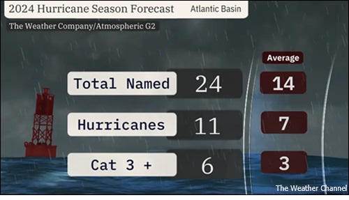
The 2024 Atlantic hurricane season could be one of the most active on record, according to a new outlook issued Thursday from The Weather Company and Atmospheric G2.
It’s the most aggressive hurricane prediction since outlooks began in 2006. Big numbers likely this year: The outlook issued on Thursday calls for 24 named storms, 11 of which will become hurricanes and six of which will reach Category 3 status or stronger. That is well above the 30-year average tally for both hurricanes and storms, and also markedly above the tally of 20 storms, seven hurricanes and three Cat 3-plus hurricanes in 2023. “Most of the evidence is lined up to suggest a very active and very impactful hurricane season in 2024,” say the forecasters at Atmospheric G2. Bigger impact likely this year: Forecasters are also worried about more landfalls this season due to a troubling setup for storm movement. In a complete flip compared to last season, a stronger high-pressure system is expected to set up shop near Bermuda and the Azores, which should deflect more storms westward toward the Caribbean and the United States. This combination of more storms and this pattern will lead to more storms nearing coastlines. Confidence grows that we’ll have to use a second list of names: All other groups that have issued outlooks so far have predicted that we’ll use at least every name on the 2024 names list. -Colorado State University: 23 storms, 11 hurricanes, 5 major hurricanes -Tropical Storm Risk: 23 storms, 11 hurricanes, 5 major hurricanes -University of Arizona: 21 storms, 11 hurricanes, 5 major hurricanes Each year, there's a list of 21 Atlantic Basin names that repeat every six years, unless one or more of them is so deadly and/or destructive that its name is retired. So if we use up all names through "William" this year, a supplemental names list will be tapped, beginning with "Adria." Only two other Atlantic hurricane seasons in which names have been used have pushed beyond 21 storms: 2005 (28 storms) and 2020 (30 storms). There are two primary reasons behind these turbocharged outlooks. 1. The Atlantic's record warmth: Hurricane season generally begins when water temperatures warm to around 80 degrees, which usually occurs between June 1 and Nov. 30. If other factors are equal, the deeper and warmer ocean water is, the stronger a hurricane can become. Water temperatures in the North Atlantic Ocean continue a 400+ day streak of being record warm, according to University of Miami tropical scientist Brian McNoldy. This unusual spring warmth stretches from the Gulf of Mexico to Africa. Water temperatures in the Atlantic’s Main Development Region (MDR), which stretches from the Lesser Antilles to West Africa, is as warm as it should be in late June or early July. 2. El Niño is likely to become La Niña: This matters because it's one of the strongest influences on hurricane season activity. In general, La Niña Atlantic hurricane seasons have less wind shear that can otherwise rip storms apart, and rising, unstable air that is more conducive for thunderstorms, the building blocks of tropical storms and hurricanes. So this means instead of El Niño acting as a gentle brake on hurricane season, La Niña could instead step on the gas pedal. (Source: The Weather Channel) Story Date: April 19, 2024
|
      |