|
|
|
|
|
|
| May 19, 2024 |
|
‘High risk’ of severe storms in Plains, with ‘intense’ tornadoes possible 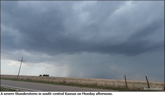
A significant severe storm outbreak is underway first in the Plains and Central U.S., and eventually reaching the Ohio River Valley.
The Storm Prediction Center raised the risk level to "High," the most significant level on its risk scale that is rarely used, due to the tornado threat in central Oklahoma and southern Kansas Monday into Monday night. Locations in the high risk area include Oklahoma City, Norman, Okla., Moore, Okla., and just south of Wichita, Kan. "A regional outbreak of severe weather with multiple strong, long-tracked tornadoes, as well as very large hail and severe thunderstorm gusts, is expected over parts of the south-central Plains from this afternoon through evening," the NWS warns. While the most intense storms are likely to hit Oklahoma and Kansas, severe weather is possible from Texas to Missouri northwestward into South Dakota on Monday. The first tornado watches of the day went up in Nebraska and Kansas in the early afternoon. A "Particularly Dangerous Situation" tornado watch is in effect for central Oklahoma, including Oklahoma City, through 11 pm central time, where "explosive development" of severe thunderstorms is forecast, SPC stated. The likelihood of EF-2 or stronger tornadoes in this region is assessed as "high." Computer models are pointing to a rare high-end threat of tornadoes, on par with some notorious past events in this region. The storms are the result of a clash between a cooler, much drier air from the west clashes with a fast-moving warm, moist air flowing north from the Gulf of Mexico and spreading across much of Texas, Oklahoma, Kansas and Nebraska. The presence of strong winds well above the surface, associated with a dip in the jet stream, will help trigger severe thunderstorms and give them the energy needed to become supercells, which are thunderstorms that contain persistent, rotating updrafts. The upcoming outbreak follows a busy April, during which more than 300 tornadoes were reported across the country. This may be the first "high risk" outlook for Oklahoma in five years, illustrating the seriousness of this situation. The Storm Prediction Center, which issues tornado watches across the U.S., also has issued a "moderate risk" outlook for other areas on Monday, which is a level 4 out of 5 on its risk scale. This region includes Tulsa, Okla. and Wichita, KS. A broader area of "Enhanced risk," which is a level 3/5, includes Kansas City, MO, Lincoln Neb., Springfield, MO, and Kansas City, KS. At least 70 million people are in a "slight risk" or greater threat level for severe weather during the Monday to Wednesday period, according to the SPC. The storm threat will not end at sunset. "While the environment during the afternoon will certainly support intense, long-track tornadoes, concern only grows by early evening," the SPC stated in an online forecast discussion. The severe weather threat is expected to move east for Tuesday, with cities including Indianapolis, Columbus, Memphis, Nashville and Cincinnati all at risk for storms. Wednesday could also bring a more significant storm risk. (Source: Axios) Story Date: May 7, 2024
|
      |